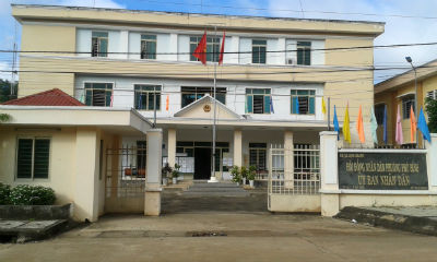
1. GEOGRAPHICAL LOCATION
Phu Binh is located at the heart of Long Khanh town
and has the area of natural land of 231.7 hectares.
+ Phu Binh borders Xuan Hoa ward and Xuan Tan
commune in Long Khanh town, Dong Nai province to the north;
+ Phu Binh borders Xuan Tan commune in Long Khanh
town, Dong Nai province to the south;
+ Phu Binh borders Bau Sen and Xuan Tan communes in
Long Khanh town, Dong Nai province to the west;
+ Phu Binh borders Xuan Tan commune in Long Khanh
town, Dong Nai province to the east.
2. ADMINISTRATIVE UNIT
Phu Binh is divided into two areas: Quarters 1 and
2.

3. TERRAIN
Phu Binh is an agricultural ward.
4. CLIMATE
Phu Binh is located in the tropical equatorial
monsoon climate with the climate characteristics of the Southeastern region,
which is divided into two distinct seasons: the rainy season and the dry season.
The rainy season is from May to November.
The dry season lasts from December to the end of
April next year.
The average humidity: 80 - 82%
The average temperature: 25 - 27 Celsius degrees.
The highest temperature: 29 Celsius degrees.
The lowest temperature: 20 Celsius degrees.
5. HISTORY AND CULTURE
The People’s Committee of Phu Binh ward was
established in 2004. The people settling in Phu Binh ward include the people
from the provinces and cities across the country and they have arrived here to
make a living, but still retained their tradition of patriotism and a high
revolutionary spirit. In general, the life of the majority of locals is stable
and gradually developed.
Phu Binh has 2 pagodas and 1 monastery and religious
activities are operating stably and have strictly followed the Party’s
guidelines and the State’s policies and laws.
6. POPULATION
Phu Binh’s total population is 1,211 households with
5,298 people and Phu Binh has a lot of ethnic minority groups, most of whom are
Kinh people, accounting for 53%, Chinese Vietnamese accounting for 37%, and
others like Nung, Tay, Khmer, Choro and Muong.